Geospatial Asset Management is a technology that effortlessly helps you locate and monitor the condition of your assets.
Key aspects of Geospatial Asset Management include:
- Seamless tracking
- Utility Mapping
- Work order creation
- Accurate reporting
What is GIS Data?

GIS Data, or Geographic Information Systems Data combines geospatial information with specific data pillars. This means it can correlate various data points with geographical elements or locations on a map. Here's how it works:
- GIS Data enables us to capture and store geographical information.
- GIS Data has the ability to manipulate and analyze the data collected.
- GIS Data allows us to visualize data.
The Role of GIS Data in Asset Management
Asset management is all about tracking and monitoring resources or items of value that belong to a business. It's not just about knowing where your assets are, but also getting insights about their performance. And that's where GIS comes into play. GIS gives you better visibility into your assets, allowing you to monitor their deployment and arrange them efficiently.
Here are some key features that make GIS a must-have tool for asset management:
- GIS provides real-time monitoring and big data logic, helping businesses prioritize according to their needs.
- It creates regions to log, display, and allocate information about an asset, and enables better organization and management of assets.
- GIS automates mapping and aids in transport asset management.
- GIS creates Smart maps and online dashboards and allows supervisors to have an expansive view of their assets.
- It has the ability to analyze and collate different types of assets to uncover correspondence, drawbacks, and patterns.
Now, let's dive into the pros and cons of using GIS in asset management:
Pros:
- Enhanced Visibility: With GIS, businesses can track the location and performance of their assets in real time, allowing for prompt and effective decision-making.
- Cost and Time-Efficiency: GIS mapping automates many manual activities related to asset management, reducing labor costs and saving time.
- Optimal Utilization: GIS monitors the deployment of resources and ensures assets are employed optimally and maintenance is updated.
- Improved Planning and Decision-Making: With its ability to analyze different types of assets and uncover patterns, GIS facilitates investment strategies and resource allocation decisions.
- Comprehensive Understanding: GIS-based smart maps and dashboards provide a broad perspective of all assets, helping leaders to maintain their asset's strength effectively.
Cons:
- Dependence on Connectivity: GIS applications require reliable internet connectivity for real-time asset tracking, which may not be possible in remote or underserved areas.
- Cost of Implementation: Although cost-effective in the long run, the initial cost to integrate GIS into asset management can be high.
- Data Management Challenges: GIS can collate vast quantities of data, which could potentially lead to storage and management issues in the absence of strong data
Benefits of Using GIS Data for Asset Management
1. Better Understanding of Assets and Their Lifecycle
When you understand your assets and their lifecycle, you can maintain operation efficiency and minimize business costs. Harnessing Geographic Information Systems (GIS) data for asset management can offer a comprehensive view of your assets, enhancing their tracking, performance, and longevity.
Here's how you can smartly use GIS data for thorough asset comprehension:
- Identify and Track Assets: You need an efficient way to identify and track your assets, especially if they are spread out over a large area. GIS data aids in providing a spatial perspective, pinpointing the precise location of your assets.
- Analyze Asset Data: GIS data offers other asset attributes such as air pressure, temperature, and operational status. This allows for a more detailed analysis of your asset’s performance in real-world conditions.
- Regulatory Compliance: It's key to capture and maintain the traceability of asset data, which can help in regulatory and government requirements.
- Visualize and Report: GIS presents asset data in visually convenient maps that aid in better decision-making, management, and maintenance planning.
2. Increased Efficiency and Productivity of Field Inspections
These inspections have been wrought with various challenges such as an extensive array of assets, environmental factors, compliance issues, and inconsistent asset inventory. However, the introduction of GIS data has transformed the way these field inspections are performed, making them more efficient and productive.
Here's how:
- Effective Asset Tracking: One of the primary ways GIS data enhances efficiency is through its ability to visually track assets. Whether it's utilities, buildings, or parks, GIS data provides a real-time visual representation of these assets. This not only aids in proactive maintenance but also in prioritizing capital improvements, especially in cases of vast assets.
- Insightful Data Analysis: GIS data, with its spatial data analysis capabilities, allows for predictive operations and maintenance. This helps take proactive measures, mitigate risks, and reduce downtime.
- Comprehensive Infrastructure Mapping: Infrastructure, whether it is stormwater, sanitary sewer, or potable water, can be accurately mapped with GIS. This provides a holistic view of the asset network, enabling better planning and maintenance.
- Streamlined Work Order Management: GIS solutions pull all important data together on a single platform and facilitate efficient work order management. Field officers can thus manage municipal operations more effectively, saving time and resources.
- Enhanced Stakeholder Feedback Collection: GIS data allows businesses to crowdsource reporting, facilitating the collection of actionable stakeholder feedback. This contributes to maintaining a consistent shared view of the network model.
- Improved Compliance and Safety Measures: With GIS data, field inspection teams can maintain traceability of asset data, gain better detailing of facilities, and satisfy requirements laid down by regulatory bodies.
3. Improved Data Consistency and Quality
This data enhancement significantly impacts various aspects of an organization.
- High-quality and consistent data helps to mitigate risks and aids in making informed decisions.
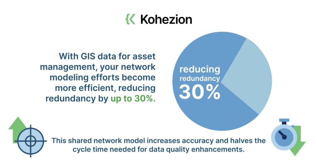
- With GIS data for asset management, your network modeling efforts become more efficient, reducing redundancy by up to 30%. This shared network model increases accuracy and halves the cycle time needed for data quality enhancements.
- GIS data greatly alleviates problems associated with extensive assets, environmental factors, compliance, and varying levels of asset inventory.
- Solutions such as mobile and aerial mapping provide high-resolution, georeferenced 3D imagery.
- Improved data consistency and quality strengthen the reliability of asset data and help mitigate organizational risks. With consistent, high-quality data, you stand a lesser chance of losing valuable opportunities or financial resources due to inaccurate or incomplete information.
- It enhances efficiency in managing network modeling efforts. GIS data enables a shared view of the network model across the enterprise, reduces redundant network modeling efforts by up to 30% and improves data quality enhancements by up to 50%.
- GIS data can help comply with regulatory requirements. Being able to capture and maintain traceability of asset data can meet the mandates set by various regulatory and government agencies. It allows digital workers to inspect and perform geospatial asset-based tasks on a consistent, shared view of the network model.
- It aids in overcoming challenges posed by complex asset management scenarios, like dealing with extensive assets with limited resources, weather and seasonal variations, compliance and safety issues, and differing levels of asset inventory.
- Thanks to improved data consistency and quality, risks can be significantly reduced. By having a gold standard of data quality, your organization isn't just safeguarding its data but also protecting itself from lost opportunities and financial setbacks.
4. Increased Visibility and Transparency of Assets
GIS offers unparalleled visibility and transparency on the whereabouts and performance of your assets.
- Integrating GIS with asset management pinpoints the exact location of assets, offering a whole new level of visibility.
- GIS is designed to record other attributes such as air pressure and temperature. This way, you'd have a clear understanding of how weather patterns could impact your assets, enabling you to act accordingly.
- With GIS data, you can monitor compliance efficiently, ensure safety measures are adhered to, and manage asset inventory effectively.
- GIS documents the location, resources, and condition of assets over time and forms a complete traceable record.
5. Enhanced Decision-Making Capabilities
The top features of GIS data that contribute to better decision-making include:
- Rich data collection: GIS provides intricate data about asset features, conditions, and other parameters.
- Spatial orientation: It captures the geographical location and extent of assets.
- Analytics: It helps in evaluating and predicting trends.
- Visual summary: Maps and other visual representations aid in understanding complex data.
- Integration with other systems: GIS can easily communicate with other software and databases, marrying multiple data sets together for a comprehensive view.
Pros:
- Enhanced Understanding: Visual maps and analytics offer a clearer understanding of asset details and their surroundings.
- Progressive Forecasting: Predictive models can forecast asset life and potential risks.
- Real-Time Tracking: Real-time changes can be documented and monitored.
- Improved Collaboration: Allows for a shared view of assets across departments, improving communication and collaboration.
- Time and Cost Efficiency: Streamlines processes to reduce cycle times and costs.
Cons:
- Initial Setup: Setting up GIS infrastructure can require significant initial investment.
- Data Overload: Working with numerous data can sometimes cause confusion.
- Software Complexity: It may take time to learn and become comfortable with the software.
- Continual Updates: Maintaining the currency of data requires continuous effort and resources.
- Dependence on Data Quality: The accuracy and usefulness of GIS depends heavily on the quality of the input data. Inaccurate or outdated data will produce misleading results.
6. Improved Understanding of Risks, Costs, and Returns
The benefits of using GIS data in understanding risks, costs, and returns can be categorized as follows:
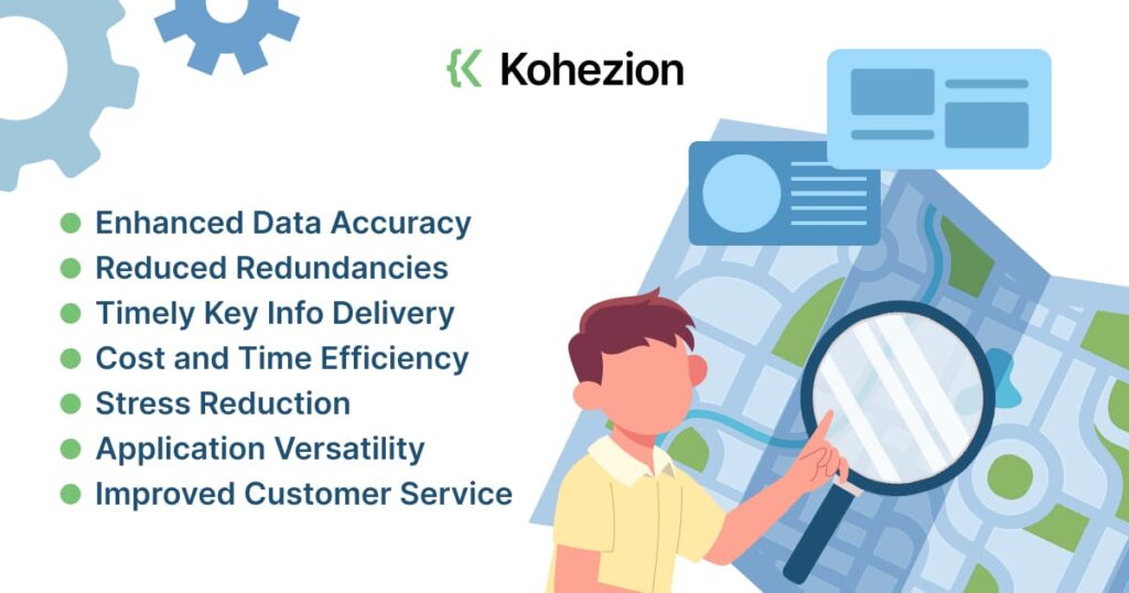
- Enhanced Data Accuracy: GIS offers an easier way to collect precise data, map traffic and other conditions, and zero in on potential risks ahead of time.
- Reduced Redundancies: GIS enables a consistent network model across the enterprise, reduces redundant network modeling efforts by up to 30%, and improves overall accuracy with a shared view.
- Timely Key Info Delivery: The GIS framework documents the location and extent of resources and assets, tracks their condition over time, and creates visual reports summarizing important information.
- Cost and Time Efficiency: This system enables businesses to make optimal decisions about where to place new projects while reducing time spent on finding hard-to-access information.
- Stress Reduction: With the help of GIS, your team's stress can also be reduced as it brings in the accuracy of data while increasing the efficiency of your processes.
- Application Versatility: Whether it's building inspections, forestry management, or managing critical drinking water operations, GIS data provides the required inputs to make better decisions, ensuring optimal health and functionality across various domains.
- Improved Customer Service: With the timely and accurate management of assets, companies can also improve their customer service, ensuring the right fixes at the right time in the right locations.
7. Increased Collaboration and Communication
In essence, GIS data visualization dynamically represents spatial relationships among managed assets. This interactive quality brings about a shared perspective that fosters collaboration and open communication, nudging us towards a harmonized workspace. It opens avenues for effective work planning and an in-depth analysis of the asset environment.
The fusion of app integration platforms, like Zapier, Integromat, or Snaplogic, with advanced GIS solutions, presents an extremely intuitive ecosystem to smoothly navigate assets. Let me paint you a picture here. In the telecommunication sector, for instance, we are privy to convoluted networks, numerous assets, and an overwhelming data influx. GIS allows seamless "conversations" between applications, removes redundancies, and evolves toward a unified workspace. This encourages teams to collaborate in real-time and fosters open communication about network data and assets.
8. Increased Safety and Security of Assets
When you utilize GIS data, you're not only smarter about asset tracking, but you also significantly increase the safety and security of those assets. Here's how:
- Enhancing Traceability: GIS data satisfies the requirements placed by regulatory and governmental bodies, ensuring assets are properly tracked and managed.
- Unified View of Assets: GIS offers a single, understandable view of network assets across the enterprise, enabling inspection and other asset-based tasks to be performed on a consistent, shared network model.
- Location-Based Asset Management: The framework documents the location and extent of resources and assets, tracking their condition through time. You end up with a visual report summarizing key information that helps manage informational, service, and maintenance work. And it all happens right where the asset is located.
- Greater Efficiency: Geospatial Information aids in better customer service and contributes to savings for tight budgets. With accurate Geospatial Information, you're able to work smarter, not harder.
- Aging Infrastructure & Regulations: Organizations with hefty infrastructures are increasingly relying on Geospatial Information to jazz up the performance of their fixed assets.
9. Increased Resource Allocation Efficiency
Geospatial Information Systems (GIS) data helps you visualize and identify spatial relationships between assets, work plans, and analysis, making it easier for you to fish out the resources you need and place them exactly where they are most needed.
Top features of GIS data that contribute to this efficiency are:
- Location and extent documentation of resources and assets
- Tracking of asset conditions over time
- Creation of tabular and map-based visual reports
- Reduction of redundant network modeling efforts
- High-quality asset collection and identification
- Integration and analysis of collected data
Pros:
- Detailed Information: GIS data provides you with a comprehensive system for organizing information about the assets, including location, proximity, adjacency, and history.
- Visualization: It enables you to dynamically visualize spatial relationships among your managed assets, work planning, and analysis, making it easier to allocate resources where needed.
- Reduction in Redundancy: It significantly reduces redundant network modeling efforts by up to 30%, freeing up time and resources for other tasks.
- Accuracy and Efficiency: It improves overall accuracy and enhances data quality, leading to improved decision-making and industry insights.
- Cost-Efficiency: It maximizes the lifespan and performance of your important assets while minimizing lifecycle operating costs.
Cons:
- Quality Dependence: The accuracy of the data is dependent upon the quality of the technologies and databases integrated with your GIS system.
- Complexity: GIS data can be complex to understand and manage if you don't have the right expertise and systems in place.
- Training: Your team would need specialized training in GIS technology in order to effectively use this data.
- Cost: Initial setup, integration, and training costs can be high.
- Constant Updates: Since GIS data is tied to physical assets, it may require constant updating to reflect real-time changes in your assets or resources.
10. Increased Sustainability and Environmental Responsibility
Top features of GIS data that contribute to sustainability include:
- Detailed spatial representation of assets
- Real-time tracking of asset conditions
- Comprehensive mapping and tabular visual reports
- Informed decision-making based on accurate data
- Capacity for customizing services to ensure responsible asset management
Key benefits of using GIS data in the realm of sustainability and environmental responsibility:
- Better Resource Management: GIS data provides a spatially accurate representation of assets and resources, enabling better management and maintenance decisions.
- Reduced Environmental Impact: With GIS data, unnecessary maintenance and replacement of assets can be avoided, leading to reduced waste and a lesser environmental footprint.
- Sustainable Asset Planning: Real-time tracking of asset conditions encourages proactive maintenance and planning, extending asset life and promoting sustainability.
- Increased Efficiency: The mapping and tabular reporting capabilities of GIS data streamline decision-making processes. This results in significant savings, reducing the consumption of resources.
- Enhanced Service Delivery: GIS data allows for customization and optimization of services based on geographic conditions, ensuring that public services are delivered in the most environmentally friendly and sustainable manner possible.
What assets will be best for geospatial asset management?

1. Infrastructure Assets
What makes managing infrastructure assets using GIS data a game changer:
- Captures comprehensive information about every asset including location, proximity, adjacency, and history
- Ability to cater to a range of industries from utilities to transportation
- Maximizes lifespan and performance of assets while minimizing lifecycle costs
- Combines mapping and spatial analysis for strategic data organization
- Comes with a built-to-customize spatially-enabled asset management framework
2. Machinery and Equipment
Let’s delve into the features that make these an ideal fit for geospatial asset management:
- Real-Time Tracking: Machine equipment comes with tracking features enabling real-time supervision of assets and inventory.
- Capabilities for Detailing: Equipment and machinery can provide detailed visualization of facilities such as workshops and multi-story buildings.
- Enhanced Field Service: This equipment helps map out customer locations, facilitating field service, maintenance, and utility operations.
- Supportive Tools: These assets often come equipped with IT hardware and software tools, giving a digital edge to asset management.
Pros:
- Accurate Data: They give you precise geospatial data, reducing discrepancies in asset management.
- Efficient Workflow: With all vital information at your fingertips, machinery and equipment streamline workflow significantly.
- Time-Saving: With faster data processing and task automation, these assets save valuable time.
- Better Quality Control: An effective tracking system in these assets allows you to monitor quality and promptly spot any issues.
- Improved Planning: They help in mapping out key details like soil conditions which assists in planning and development stages.
Cons:
- Upfront Costs: The initial purchase and setup costs for these assets can be high.
- Staff Training: There may be training required to use the machinery and software tools effectively.
- Maintenance Expenses: Regular upkeep and maintenance of these assets can lead to additional costs.
- Tech Challenges: Technical glitches or system failures can affect data accuracy and workflow.
- Dependence: Excessive reliance on these assets might result in difficulties when they're unavailable or out of service.
3. Buildings
The physical dimensions and usability of the buildings make them an ideal asset in the vast landscape of geospatial asset management.
Some of the top features that make buildings suitable for this include:
- The distinct architectural features make each building a unique identifier on the map.
- The multi-story nature of buildings offers a wealth of layered spatial data.
- Buildings house various equipment, machinery, and IT hardware, providing detailed data for asset management.
- Buildings often function as vital community resources such as schools, hospitals, and libraries, making them crucial elements to include in any mapping system.
- With the use of software tools and apps, maintaining up-to-date information about buildings becomes easier.
Pros:
- Facilitates an efficient record of building inspections as updates can be done in real time.
- Provides detailed spatial data and enables the prioritization of capital improvements.
- Enhances operational efficiency with a comprehensive view of the physical structure and its facets, simplifying maintenance.
- Offers a central platform for customer service and efficient work order management.
- Optimize new build plans and promote sustainable development.
Cons:
- The need for updating the database with recent changes in the building or its infrastructure can be resource-intensive.
- Decisions based on the geospatial data need to take into account a multitude of variables, which can sometimes lead to complex decision-making processes.
- It can get complicated to maintain the accuracy of data, considering the constant evolution of software tools and apps.
- Technical glitches in IT hardware, software, and applications can disrupt the smooth functioning of asset management.
- Insufficient or incorrect data can lead to sub-optimal decisions that could increase expenditure in the long run.
4. Utility Lines
Here's what makes utility lines a top pick:
- They cut across both the built and natural environment, making them an excellent source of spatial data.
- Utility lines include everything from water, gas, and electric utilities to storm and sanitary lines.
- We can use them in numerous applications, such as soil condition mapping for water pipe placement.
- They're invaluable for businesses that need to capture, map, and manage tangible assets in various geographic locations.
- They help in creating an intuitive solution to streamline design, and data capture workflows and ensure accuracy and completeness of utility or telecommunications network representation.
Pros:
- Utility lines give you a wide range of spatial data.
- They cover different types of utilities.
- Can be used in various applications.
- They are vital for businesses requiring geographic data capture and asset management.
- Aids in creating an accurate and complete representation of utility networks.
Cons:
- If not managed carefully, this vast amount of data can be overwhelming.
- It requires specialized knowledge to interpret and manage each type.
- The wide range of applications may require different approaches for data analysis.
- Not all businesses may have the necessary resources for effective geospatial management.
- Errors in representation can lead to significant inaccuracies, affecting decisions based on this data.
5. Transportation Assets
Features that make transportation assets suitable for geospatial asset management include:
- Location-centric nature: These assets are almost always associated with a specific location, perfect for mapping and tracking.
- Broad range: Transport assets often span across large geographical areas, benefiting from a geospatial overview.
- Maintenance scheduling: Being able to map asset locations helps in the efficient planning of maintenance work.
- Data integration: Geographic Information Systems (GIS) allow the integration of asset information alongside location, making comprehensive data readily available.
- Regulatory compliance: Knowing the precise location of assets can aid in satisfying requirements placed by regulatory and government agencies.
Pros:
- Enhanced Decision Making: Detailed location knowledge aids in making informed, effective decisions.
- High-Quality Data: Geospatial asset management ensures the collection and preservation of consistent, quality data.
- Increased Efficiency: Asset mapping can streamline scheduling, logistics, and maintenance tasks.
- Optimized Asset Lifespan: Precise monitoring maximizes the longevity and performance of assets
- Risk Management: Accurate asset positioning can help minimize risk and quickly address emergencies.
Cons:
- Initial Setup: Implementing a geospatial asset management system can be complex and requires substantial time and resources.
- Training Requirements: Staff will need training to use and maintain the system effectively.
- Data Accuracy: Data must be continuously updated to maintain accuracy, and mistakes can lead to misleading results.
- System Dependence: The entire operation becomes reliant on the system's functionality. System failures could disrupt the entire operation.
- Maintenance Costs: Regular system updates, hardware upgrades, and potential repairs introduce ongoing costs.
6. Landscaping Assets
Landscaping assets are the ideal choice for geospatial asset management because of their location-based nature and the strategic importance of their positioning and condition.
Here are some top features of geospatial asset management as applied to landscaping assets:
- Ability to map, monitor, and manage sprawling landscapes with ease.
- Agile management of resources through mobile data collection.
- Utilization of powerful mapping and spatial analysis tools.
- Cost-efficient tracking and recording of key asset attributes.
- Seamless integration with backend GIS, databases, or workflow.
Pros:
- Visualization: Geospatial asset management provides a visual representation of the landscape assets, making the process intuitive and more effective.
- Efficiency: Mapping landscape assets aids in quick location, saving considerable time and manpower.
- Strategic Decision Making: With spatial analysis, organizations can make informed decisions about asset deployment based on location variables.
- Cost-Savings: Efficient tracking of assets helps to eliminate unnecessary costs associated with mismanaged assets.
- Maintenance Scheduling: The system can link landscape elements with other logistical parameters like traffic or parking constraints to optimize maintenance schedules.
Cons:
- Learning Curve: Mastering the use of geospatial software tools for landscaping could be challenging for some staff members.
- Dependency on Technology: The system's effectiveness would be compromised if there were any glitches or downtime.
- Data Overload: The system could generate overwhelming amounts of data, requiring adequate management.
- Data Security: There might be concerns over the security and privacy of data, especially when stored in a cloud-based system.
- Initial Investment: Setting up the system could require substantial initial investment in software and training.
7. Construction Projects
Here's why construction gigs make a perfect match for this tech:
- It optimizes new build plans, ensuring that your network is built cost-effectively.
- It helps in the detailed planning and design of complex structures like multi-story buildings and workshops.
- It provides real-time management of building inspections.
- It aids in understanding what's underground, crucial for planning utility networks.
- Offers invaluable support for capital planning and for scheduling maintenance tasks.
Pros:
- It's a real-time solution. You can manage building inspections and other processes in real-time.
- Geospatial asset management is comprehensive. From capital planning and building inspections to underground mapping and work order management, this system can help with multiple aspects of your construction project.
- It brings efficiency. You can standardize condition inspections and ratings, maintain critical operations, and streamline recreation operations and maintenance.
- It ensures optimal asset utilization. With geospatial asset management, you can prioritize your resources effectively for optimal use and reduce waste.
- It facilitates proactive decision-making. With predictive operations and maintenance, potential pitfalls can be foreseen and avoided.
Cons:
- There's a learning curve involved. The implementation of a geospatial asset management system necessitates training for team members, which can initially be time-consuming.
- It can be expensive. The cost of purchasing and maintaining a sophisticated system like this may be a hurdle for smaller construction firms.
- It requires constant updating, which can be an issue for very dynamic projects. Data may change frequently and keeping the system up-to-date requires continuous effort.
- Being reliant on technology, the system might pose potential risks such as cyberattacks or system failure.
- As with any other technological solution, there is always the risk of technological redundancy. The system might become outdated quickly, given the fast pace of technological advancements.
8. Natural Resources
Natural resources serve as a rich reservoir of geospatial information crucial for diverse fields, ranging from agriculture to urban planning.
Pivotal features that turn natural resources into ideal assets for Geospatial Asset Management include:
- Richness in Variety: Rivers, forests, mineral resources, wind patterns just to name a few; every contrast provides unique geospatial data.
- The Base for Environmental Assessments: The geospatial data derived from natural resources is essential for environmental impact assessments.
- A Vital Source for Utilities: Cumulating geospatial data related to resources like water, gas, and electricity significantly influence their management strategies.
- Foundation for Infrastructure Planning: Data about the land, its composition, and topography contribute to safe and efficient infrastructure development.
- Valuable for Discerning Climate Patterns: A databank for tracking and monitoring climate change.
Pros:
- Broad-Spectrum Data: Unearthing geospatial data from natural resources reveals across-the-board insights beneficial for various sectors like farming, transportation, or customer service.
- Economic Feasibility: The process doesn't incur huge costs as the assets are already present in nature.
- Environment-Friendly: This method resonates with environmental sustainability as it doesn't demand industrial activity or machinery.
- Global Collaboration: The universal availability of natural resources allows international collaboration in data collection and analysis.
- Up-to-date Information: Nature changes and evolves continuously, ensuring that the geospatial data is dynamic and current.
Cons:
- Unpredictable Variables: The ever-changing nature of weather, tides, or wildlife migration can lead to inconsistent data.
- Tough Accessibility: Some resources in remote or challenging environments might be hard to reach or measure accurately.
- Natural Disasters: Events like floods, forest fires, or landslides can distort or obliterate geospatial data.
- Legal Constraints: Some areas could be protected by law, restricting access to specific natural resources.
- Dependency on Technology: Despite relying on nature, the management process is heavily dependent on advanced GIS technologies for accurate data capture and analysis.
9. Personnel Assets
Personnel assets refer to the human resources or workforce within an organization, each possessing their own unique skills, knowledge, and expertise.
We emphasize the vitality of personnel assets in geospatial asset management for several reasons:
- Comprehensive Knowledge: Personnel assets bring wide-ranging expertise in the use and interpretation of Geographic Information Systems (GIS) to the table. Their professional wisdom helps analyze the complex information gathered by GIS and harness it for smarter decision-making.
- Organizational Familiarity: Being a part of the organization, personnel assets have an in-depth understanding of internal operations, systems, assets, and procedures. Their familiarity facilitates effective and accurate asset management.
- Training and Upskilling: The workforce can be trained and upskilled in the usage and management of geospatial assets. With training, personnel assets can rapidly adapt to new techniques or software enhancements in GIS.
- Management of Assets: Geospatial asset management isn't merely about knowing the physical location of assets. It's about tracking the asset's performance too. Trained personnel assets can effectively manage these aspects.
- Problem-Solving Abilities: When a technical issue arises, it’s the personnel assets, with their problem-solving abilities and knack for innovation, who can fix the glitch. Their hands-on experience with the organization's systems allows them to troubleshoot and solve technical hiccups quickly.
- Role in Communication: Personnel assets play a key role in conveying critical information between departments, fostering a well-coordinated and sharp approach to managing assets.
10. Information Systems
Top Features of Information Systems in Geospatial Asset Management:
- Comprehensive Data Compilation: GIS enables the gathering, scrutinizing, and maintaining of data on all mappable assets such as infrastructure, utilities, etc.
- Online Data Accessibility: Information can be conveniently stored in the cloud and made available to users via different devices.
- Wide-ranging Inquiry: GIS supports a wide array of inquiries, from determining land ownership to locating the nearest water main.
- Scalability: The system can easily be scaled to suit different operational levels, from townships to counties, and can be adjusted to fit the varying needs of different professional levels.
- Engagement and Insight: Beyond being a system of record, GIS serves as a platform where data is provided to users beyond the core group, facilitating wider engagement and deeper insights.
Pros:
- Efficient Record Keeping: GIS provides a one-stop hub for measuring, recording, and tracking everything about an asset, including type, age, location, condition, work order numbers, and installation records. It even integrates data from external systems and work management.
- Enhanced Data Visualization: Asset management becomes simpler and more intuitive, with easy visualization of asset location and related information. This system facilitates comprehensive engagement with data, helping managers and employees get a better handle on the spatial dynamics of their assets.
- Increased Accessibility: The cloud-based nature of GIS allows for easy access to vital data on a variety of devices, keeping key stakeholders abreast of the location and status of assets.
- Improved Operations Awareness: GIS enables the use of performance data to evaluate employees and boost operations awareness, leading to improvements in efficiency and productivity.
- Greater Scalability: Whether you're dealing with asset management for a small township or a large county, GIS can be scaled up or down to suit your needs, offering easy customization and scalability.
Cons:
- Cost Implications: Particularly for small organizations, the cost of implementation and maintenance of a GIS can be challenging.
- Complex Usability: While GIS provides invaluable insights, it can be challenging to use, especially for individuals with limited technical proficiency.
- Data Security: Since GIS often involves storing sensitive information in the cloud, there's a risk of data breaches or loss, which may have significant implications for an organization.

Case Studies of Successful Geospatial Asset Management
1. St. Louis Water Division
St. Louis Water Division's primary responsibility is maintaining the health and functionality of the water systems in St. Louis. But boy, did they have their hands full. The challenge? Keeping track of, monitoring, and generally managing all of these assets was a mammoth task. We're talking water treatment plants, storm & sanitary utilities, gas & electric utilities, not to mention streets, highways, buildings, and equipment.
Gateway to the West reeled in GIS data for managing their assets.
How does this work, practically? The folks in field operations have tablets loaded with a dynamic GIS map. They're out inspecting a storm sewer. They find a problem, maybe some deterioration that needs attention. They snap a picture, note down the condition, and capture the location - all there on site. With a few taps, they upload all this into the GIS system. Now, they've got a real-time log, and back at HQ, the team sees the update and promptly plans needed maintenance or repair.
The St. Louis Water Division didn't just come out of this with a shiny new system: they experienced some serious perks. Let's dive into their benefits, one by one.
- Improved Efficiency: The GIS system drastically cut down their paper trail, making data collection swift and painless.
- Proactive Maintenance: Having all those assets mapped helped them spot issues well ahead of time saving not just money, but also preventing any unfortunate roadworks-related traffic headaches.
- Better Decision Making: Accurate, real-time, and accessible data led to smarter asset management decisions.
- Enhanced Customer Service: Provides an almost real-time update on a customer's issue and its resolution.
- Cost Saving: The system allowed for predictive and proactive maintenance, reducing unnecessary costs associated with large-scale, unforeseen damages or replacements.
2. Baltimore Department of Public Works
At the heart of Baltimore City, the Department of Public Works (DPW) embarked on a journey to upgrade its system and successfully rolled out a geospatial asset management system.
The key features of Baltimore DPW's geospatial asset management system include:
- Comprehensive maintenance of water, storm, and sanitary utilities,
- Integrated management of gas and electric utilities,
- Efficient supervision of streets and highway maintenance, rehabilitation, or replacement,
- Detailed monitoring and maintenance of buildings, equipment, and facilities,
- Effective customer service and work order management.
The benefits that the Baltimore DPW gained from the successful implementation of a geospatial asset management system are:
- Enhanced Efficiency: The GIS-based system encouraged a swift shift from paper to proactive management, boosting operational efficiency.
- Improved Customer Service: Real-time data enabled more responsive customer service and quicker resolution of work orders.
- Asset Optimization: The GIS-driven tool allowed for more detailed and accurate management of assets, ranging from utilities, and street maintenance to buildings and facilities.
- Informed Decision-making: The availability of geospatial data facilitated better planning decisions, thus minimizing the risk of unforeseen expenses or complications.
- Cost-effectiveness: GIS utility mapping maximized productivity while minimizing costs, leading to substantial savings over time.
However, the journey wasn't without its challenges. Implementing a system-wide change presented a steep learning curve for everyone involved. Training personnel on GIS technology, while necessary, proved to be both time-consuming and challenging. Plus, ensuring data accuracy during the transition period was a significant task to handle.
3. Santa Monica Sustainability Office
The focus here is all about building robust systems and transforming outdated methods to ensure safe, resilient, and sustainable services. One of their crowning achievements? Implementing geospatial asset management.
Here are its top features:
- Leveraged GIS utility mapping for efficient management of utilities
- Real-time tracking of building inspections
- Interactive interface for research and display of zoning and land use
- Proactive and predictive operations for maintenance, thanks to Spatial Data Analysis
- Effective capital planning to prioritize improvements
- Stormwater, sanitary, and potable water infrastructure management
Now, there are a number of benefits – but they didn't come without challenges.
- GIS Utility Mapping: The benefit of this is that it eases the process of separating storms from sanitary sewers. However, the challenge faced was getting accurate and timely geographical information about locations and assets.
- Real-Time Building Inspections: This provides prompt reaction to issues with building conditions. The challenge, however, was developing a system for real-time updates, a task that required significant technological enhancements.
- Interactive Interface: The benefit here lies in the power of visualizing data, making it easier to understand zoning and land use. The challenge? Ensuring accessibility and user-friendly design of the interface.
- Spatial Data Analysis: This enables predictive, proactive maintenance – a win for efficiency. The trade-off? The need for continuous data collection and analysis, which required significant resources.
- Capital Planning: Prioritizing capital improvements became much more manageable with this feature. But getting the right data to inform these decisions? That was the tricky part.
- Infrastructure Management: This feature makes it possible to maintain critical operations more effectively. Yet, the challenge lies in getting an accurate inventory and regularly inspecting these utilities.
4. New York City Department of Environmental Protection
The New York City Department of Environmental Protection is a pivotal organization dedicated to the management of a wide range of utilities, including water treatment, storm and sanitary utilities, and gas and electric utilities. It is also responsible for the maintenance of facilities, streets, and highways, alongside managing customer service operations.
The department identified the need for a strategic approach to manage the vast array of assets. This involves comprehensive planning for their maintenance, rehabilitation, replacement, and efficient work order management.
The GIS acts as a dynamic asset management system, allowing the department to move from paper to proactive. The department can employ GIS and use a geospatial asset management system where utilities and assets are pinpointed on a geocoded map.
- Collection and Usage of GIS Data: The New York City Department of Environmental Protection gathered data about assets such as streets, buildings, and utilities, and deployed GIS to map their locations and conditions. This data not only facilitates in-depth visual inspections but also proactive maintenance and operations.
- Improving Decision Making: The GIS-based asset management allows the department to make informed decisions about potential rehabilitation projects, and efficiently manage resource allocation. Data related to the condition of utilities and roadways, for instance, is easily accessible, streamlining the decision-making process.
- Enhancing Work Order Management: The GIS-fueled asset management system also boosts the department’s work order management. Information about an asset's location, condition, and operational status helps in itemizing and prioritizing the execution of work orders.
- Increasing Operational Efficiency: The GIS-based asset management has transformed the operations of the New York City Department of Environmental Protection, significantly raising their efficiency levels. The department can readily access and edit data, customize maps to meet varying needs, and manage resources effectively.
- Training and Support: Implementing the GIS-based system called for adequate training for staff. Operations personnel, engineers, and Program Administrators received necessary guidance on using the web-mapping services, editing data, and publishing map services.
5. Portland Water Bureau
The Portland Water Bureau was previously facing a myriad of complex challenges. Service interruptions, overflows, and maintenance snags were just a few of the recurring problems the Bureau encountered. A significant part of the Bureau's woes resulted from its outdated system of manually mapping, monitoring, and maintaining its water service assets.
The implementation process leveraged first-hand experience, expert knowledge, and client-focused problem-solving. Field officers of the Bureau started familiarizing themselves with the geospatial data collection process. Concurrently, GIS experts and software engineers set about tailoring the ArcGIS system to match the Bureau's specific requirements.
Key features of the implemented ArcGIS system included:
- Real-time situational awareness through Operations Dashboards
- Water and storm & sanitary utilities mapping
- Storm & highway maintenance and rehabilitation mapping
- Efficient customer service & work order management
- Regular building, equipment & facilities maintenance
The Bureau's effort was met with several distinct, measurable benefits:
- Improved Efficiency: The Bureau integrated geospatial asset management and managed to streamline its operations. This reduced service interruption times and aided rapid disaster recovery.
- Cost Savings: Streamlined operations and better decision-making, driven by real-time data, led to substantial cost savings in maintenance and operational activities.
- Enhanced Resource Management: The system provided useful insights to manage resources better and allocate them where they were most needed.
- Risk Mitigation: Geospatial data tracking helped to identify, assess, and mitigate risks in advance, minimizing potential damages.
6. Omaha Public Works
Omaha Public Works faced a myriad of challenges that ranged from managing water, storm, and sanitary utilities, to handling gas and electric utilities and keeping up with maintenance, rehabilitation, or replacement of streets and highways, it was a complex task. Not to mention the need for efficient building, equipment, and facilities maintenance, smooth customer service, and work order management.
To overcome these challenges, Omaha Public Works leveraged technology to its advantage, considering its successful history with asset management projects since 1995. They turned to mobile LiDAR for mapping and implemented tools like the HyRoad and NightRider software applications. They tried out different asset management systems, even creating a Sign Inventory Management System and a Statewide Sign Management and Asset Inventory System.
So, after all the hurdles, what did they gain? Here’s a concise breakdown:
- Enhanced Efficiency: With geospatial asset management, the task of locating utilities, wetlands, and other assets became much easier.
- Saved time and resources: The data they needed became readily accessible, saving valuable time and money.
- Reduced issues: Knowing the location and condition of assets at the beginning of a project significantly reduced potential problems down the line. They knew what they were dealing with from the start, which minimized surprises during the implementation phase.
- Precise Planning: They could make well-informed decisions about the placement of roads, buildings, and parks. Whether considering the implementation of a utility or the preservation of a forest, they had the reliable data they needed.
- Streamlined Operations: Handling a variety of responsibilities like building inspections, capital planning, or even forestry management, and operations became a lot smoother. High-quality information led to improved decision-making and efficient operational management.
- Proactive maintenance: They could maintain their assets, whether it's potable water infrastructure or sanitary sewer infrastructure, more effectively. The comprehensive mapping provided them with an overview of what needs attention and when.
- Efficient work order management: Managing municipal operations and customer service becomes more organized and efficient with the use of geospatial tools.
7. Kansas State University
Kansas State University, renowned by many, is a pioneering example of how geospatial asset management can lead to true innovation and efficiency.
- Establishing the Need for Geospatial Asset Management: The university recognized the need for a comprehensive and spatially intelligent asset management solution. With sprawling campuses and numerous facilities spread out, managing and tracking assets in real time was a real challenge.
- Defining the Project: They defined the project's goals. This involved coordinating with various departments throughout the campus to ensure everyone’s needs would be met. A tip for you: always collaborate cross-functionally to ensure you're addressing every critical need.
- Choosing the Right Solution: Once the foundation was set, they went on a hunt. They needed software that offered dynamic, real-time, and spatially intelligent asset tracking. After a stringent process, they landed on a solution that offered all these capabilities.
- Implementing the System: They implemented their chosen system university-wide. But, with every new system, implementation isn’t always smooth sailing. Some employees initially hesitated to adapt to the new system. The trick to winning the game is to offer effective training and continuous support. That's exactly what the university did to encase the transition.
- Evaluation and Tweaking: After implementation, the administration continuously evaluated the system, tracking performance periodically. They investigated any problems or bottlenecks and tweaked the system for better performance.
- Securing Continual Training and Support: They provided ongoing training and support for their staff. This really helped in overcoming the initial hiccups that always come with change.
8. Carlyle Plant
Carlyle Plant has a variety of assets; from infrastructure, utilities, and properties, to more intricate details like IT hardware, software tools, and even fleet assets. They found themselves in a pickle as they struggled to manage these diverse assets scattered across workshops and multi-story buildings.
Geospatial Asset Management was a practical and innovative approach for Carlyle's asset management. It set about providing a comprehensive and mapped view of their assets, thus making life much easier for Carlyle.
The Geospatial Asset Management system came packed with tools and facilities that were downright impressive. The system provided real-time visibility of assets, scheduled maintenance, easy access and update of asset data, and the ability to integrate with a variety of software apps.
Let's dive into an expanded list of pros and cons of implementing Geospatial Asset Management.
Pros:
- Easier Asset Tracking: A massive relief right off the bat - it was much easier to keep a bird's eye view of all assets scattered across multiple locations.
- Improved Maintenance Scheduling: Maintenance became a breeze with all due dates, logs, and relevant information available at a glance.
- Reduction in Losses: The system significantly reduced losses due to misplaced or unused assets.
- Real-Time Data: Real-time asset data took decision-making speed to a light-year level.
- Multi-Software Compatibility: The cherry on top - it integrated seamlessly with various software apps, equipping Carlyle with the tools needed to manage their assets comprehensively.
Cons:
- Steep Learning Curve: New technology, new problems. The software required a significant amount of training and adaptation.
- Implementation Costs: Upfront cost was a downer. Implementing the software needed some deep pockets.
- Integration issues: Despite promising multi-software compatibility, there was the occasional glitch in integrating with certain software systems.
- Lack of Customization: Some found the system’s lack of customization features a hard pill to swallow.
- Over-Relevance of Data: With real-time data updates, asset managers were sometimes inundated with information, leading to data overload.
9. The Metropolitan District Commission of Greater Boston
The Metropolitan District Commission (MDC) of Greater Boston is known for comprehensively managing essential services such as water treatment, highways, and facilities maintenance. Yet, overseeing such operations became increasingly complex until MDC accepted the challenge head-on and embraced the power of Geospatial Asset Management. Let's walk you through their journey, step by step.
- Recognizing the Challenge: First, the MDC quickly realized that their legacy systems were considerable hurdles in achieving streamlined workflow and improved decision-making. Paper-based and inflexible systems were not cutting it anymore. Thus, they needed a more dynamic, robust, and efficient management system.
- Exploring Potential Solutions: The MDC then began to extend its gaze toward possible solutions and zeroed in on Geographic Information Systems (GIS) for asset management. With this technology, they aimed to provide accurate and timely data for the management of their vast array of assets.
- Partnering with the Right Consultants: MDC partnered with Massachusetts-based firms like GPI, which offered a suite of GIS and asset management services. These collaborations guaranteed that the commission had the skilled resources necessary for successful implementation.
- Implementing the System: Next came the arduous task of moving from paper to proactive. The transition was not a cakewalk; it required mapping out their utility networks, streets, highways, and building assets into the GIS-based system. With tools like LiDAR and high-resolution imagery, along with in-house software systems like HyROADS, MDC was able to build a complete asset inventory.
- Training the Team: For the implementation to succeed, it was crucial that the system was actually used. Therefore, MDC made sure that their team was thoroughly trained to use the newly adopted GIS system. This ensured the system was not just another expensive tool sitting on the shelf, but a part of the daily routine.
- Overcoming Challenges: Despite careful planning and execution, the MDC faced some stumbling blocks. Learning curves with the new technology and resistance to change became apparent. To overcome these, they provided additional training and showcased the benefits of implementing GIS Asset Management.
10. Minnesota Department of Transportation
The Minnesota Department of Transportation employed Geospatial Asset Management systems which made a world of difference.
But it wasn't just about a fancy new technology; it was how they used it. Here's a little peek into their ingenious approach:
- Applied Light Detection and Ranging (LiDAR) data to capture high-resolution imagery guesswork.
- The in-house software HyROADS was put to good use, keeping track of inventory and such.
- They rolled up their sleeves and assessed the condition of all highway signs.
- Did an extensive inventory check along 6,000 centerline miles of their highways.
- A Statewide Traffic Signal Inventory was developed for complete asset management.
Top 5 benefits MnDOT experienced from this:
- Data accuracy and reliability: With LiDAR data and high-resolution imagery capturing the minutest details, data accuracy took a leap into the zone of impeccable reliability.
- Increased efficiency: With HyROADS, the in-house software, keeping a check on inventory, operations became smooth and efficient.
- Improved field assessment: Enabled by the Statewide Traffic Signal Inventory, field assessments transformed in their effectiveness.
- Statewide Comprehensive Management: Covering an impressive 6000 centerline miles of highways, this mighty management system ensured nothing slipped through the cracks.
- Asset longevity: With regular and detailed check-ups, the lifeline of assets was extended.
The Future of Geospatial Asset Management
Geospatial Asset Management is critical for managing everything from utility networks to transportation systems. It's all about getting accurate and timely data about your assets.
Let's unravel some trends that could be major game-changers:
- Cutting-edge technology: The advancements on the tech front are going to be revolutionizing Geospatial Asset Management. Expect to see more AI and machine learning stepping in to automate analysis and management processes.
- Improved integration and visualization: One major leap expected in the realm of Geospatial Asset Management is the enhancement of integration and visualization tools. With these upgrades, making sense of massive amounts of data and translating them into actionable insights is going to be a lot smoother.
- Transformational Technologies: The Geospatial Asset Management Summit has continuously been highlighting how flexibility will become key. The focus will be on liberating from inflexible systems and outmoded information. This will make infrastructure and services not only safe but also more resilient and sustainable.
- Innovations for Environment and Community: This one is for the urban planning, land, property, and environmental departments. In geospatial asset management, leveraging advanced software, like a property management database, can be highly beneficial. Trending on the radar is data-driven analysis for ensuring livable, inclusive, and sustainable communities. Innovations will be centered on detecting and monitoring change and applying these insights effectively.
- A Global Interactive Platform: Future developments in Geospatial Asset Management also point towards fostering an interactive environment. These gatherings will help accelerate business prospects and prepare for a sustainable future.